Day 25 Exploring around the Grampians in the rain!!!
Raining pretty well all night woke up to a very misty morning
This vehicle in my photo pulled up last night and the people just stayed in their car all night and drove off this morning
There was also another car towing a Conqueror trailer that pulled up late yesterday afternoon that pulled up right behind us that left not long afterwards

A bit of water flowing underneath the van and of course rain on top but so far all good

We decided rather than just sitting in the van in the rain all day that we would go for a drive
We decided we would head north out of the van park to drive around areas that had been highlighted for us on a map the day before

So we turned out of the campsite and headed for the Heartherlie Quarry first as it sounded very interesting. It is apparently a quarry where a lot of stone had been extracted for several major buildings.


unfortunately when we arrived at the turn off to the quarry we discovered that it was quite far to walk in and back out again.
because we weren’t sure of how bad the weather was going to get we decided we didn’t want to be away from the road for that long so we did not go in and look

Even with the rain and mist we could see some quite magnificent high mountains around us


Unfortunately we could not get views of BOM from our campsite as the signal was not strong enough so when we reached an area where there was a signal we managed to check BOM
Even with the rain and mist we could see some quite magnificent high mountains around us
Unfortunately we could not get views of BOM from our campsite as the signal was not strong enough so when we reached an area where there was a signal we managed to check BOM
Not looking good


Not far north we reached the junction to Roses Gap Road
Not far north we reached the junction to Roses Gap Road
A pleasant surprise - it was surfaced road

One of the other landmarks we were hoping to visit was the beehive falls

Unfortunately we could not drive to them

And again the distance to the falls was too far for us to feel comfortable being that far away from the road with the weather so unpredictable so sadly we never made it there either

We drove through roses gap

Just down the road I managed to get a photo of kangaroos hopping across the road
One of the other landmarks we were hoping to visit was the beehive falls
Unfortunately we could not drive to them
And again the distance to the falls was too far for us to feel comfortable being that far away from the road with the weather so unpredictable so sadly we never made it there either
We drove through roses gap
Just down the road I managed to get a photo of kangaroos hopping across the road
We have seen lots of kangaroos around this area


Another area that could have been interesting to explore but we decided against it


Came across this interesting notice on the side of the road that we did not know about

Points of Interest along the way…


must be a lot of properties along this road

Lots of water starting to pool beside the road on our way

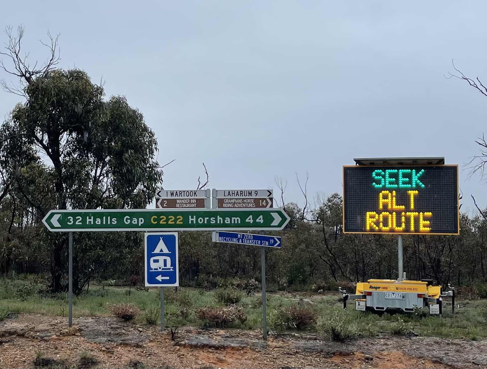
At the junction of Roses Gap rd where it meets with the highway between Halls Gap and Horsham there was this sign warning about the closure of Mt Victory rd
Another area that could have been interesting to explore but we decided against it
Came across this interesting notice on the side of the road that we did not know about
Points of Interest along the way…
must be a lot of properties along this road
Lots of water starting to pool beside the road on our way
At the junction of Roses Gap rd where it meets with the highway between Halls Gap and Horsham there was this sign warning about the closure of Mt Victory rd
Fortunately we knew about the section of Mount victory Road that was closed so we knew the way to go

What we passed through on our travels


Views across to waterfalls down the mountain side that probably aren’t normally there

We decided to turn off at this sign to MacKenzie Falls to have a look in there


Our first port of call here is the toilets but then we noticed it was only a short walk to Broken Falls so we decided to walk out to the lookout to these falls


A bit cold and wet and windy

But good view across to the falls with a lot of water gushing down over the falls


We decided not to walk as far as Mackenzie Falls but it turns out it was closed anyway


Made sure that we knew which way around that we were going back to Halls Gap via Silverband rd because of the road closure


We decided to turn off here to check out the Reids look out and the balconies


We only stopped at the Reeds look out


I took a selfie to show that all I could see behind me was mist and cloud
What we passed through on our travels
Views across to waterfalls down the mountain side that probably aren’t normally there
We decided to turn off at this sign to MacKenzie Falls to have a look in there
Our first port of call here is the toilets but then we noticed it was only a short walk to Broken Falls so we decided to walk out to the lookout to these falls
A bit cold and wet and windy
But good view across to the falls with a lot of water gushing down over the falls
We decided not to walk as far as Mackenzie Falls but it turns out it was closed anyway
Made sure that we knew which way around that we were going back to Halls Gap via Silverband rd because of the road closure
We decided to turn off here to check out the Reids look out and the balconies
We only stopped at the Reeds look out
I took a selfie to show that all I could see behind me was mist and cloud

Bill at the lookout


On the road again and we passed the turn off to Boreang campground not sure how many people are camped there but we’re glad we did not camp there

As we continued along the road it rose higher and therefore we were driving amongst mist and clouds again


We kept going past some of the featured areas that we had decided we were not going to turn off at


We eventually reached the junction where we had to turn off towards Siverband Falls due to the road closure


Noticed that there had obviously been a fire through this area as a lot of the trees were burnt

Water starting to flow across the road


And also some mud flow across the road


And mini waterfalls


And rockfalls

We didn’t stop here at these falls as we were keen to keep going as it was obvious this road was getting affected by the heavy rainfall


We did turn off to look at Lake Belfield which was obviously overflowing


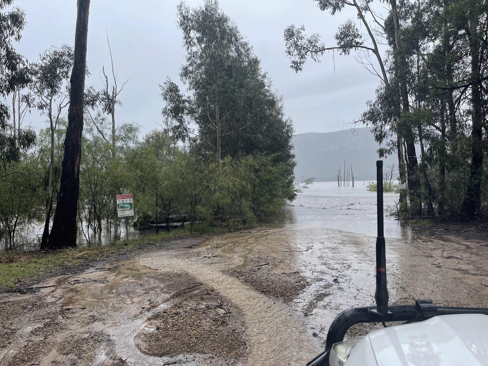
Then continuing on to Halls Gap


There was even water over the road here

We stopped off at the National Parks Centre

And spoke to the staff there to ask about where we can find out about road closures to clarify which way we will be able to travel tomorrow
They showed us the link for Vic traffic which highlights road closures as in this screen dump taken at the time which at the moment only shows the Mount victory road closure

Entrance to the Brambuk Centre

After leaving Brambuk we headed into Halls Gap hoping to call-in to the pub for lunch and a drink but unfortunately it did not open until 3 pm
Entrance to the Brambuk Centre
After leaving Brambuk we headed into Halls Gap hoping to call-in to the pub for lunch and a drink but unfortunately it did not open until 3 pm
So we then went looking for the restaurant that was supposed to be open within Halls Gap but it wasn’t open either so we ended up in what seemed to be the only place that was open, serving lunch - the Black Panther, except that we discovered that the ice cream parlour did also serve food.
However the meal that we chose was delicious even though we did not have a drink with it.
From the cafe where we had lunch we could see that the level of Stony creek flowing through Halls Gap has risen dramatically since we were here yesterday

Whilst we were able to get a Signal in Halls Creek Bill worked out a route that we could go tomorrow to reach Harrow

More photos of the creek with our car parked on the road behind

After we had lunch we walked around past the creek to the shops to pick up some supplies, mainly fruit and quick meals and wine

We popped into the information centre to see if we could use a PowerPoint in there so that I could catch up on our accounts. There didn’t seem to be anywhere suitable but then we discovered that the Paper Scissors Rock brewery was open so we went in there and asked if we could use a power point to plug a computer in. They had no problems with it and directed us to where there was a power point that we could use.
Whilst we were able to get a Signal in Halls Creek Bill worked out a route that we could go tomorrow to reach Harrow
More photos of the creek with our car parked on the road behind
After we had lunch we walked around past the creek to the shops to pick up some supplies, mainly fruit and quick meals and wine
We popped into the information centre to see if we could use a PowerPoint in there so that I could catch up on our accounts. There didn’t seem to be anywhere suitable but then we discovered that the Paper Scissors Rock brewery was open so we went in there and asked if we could use a power point to plug a computer in. They had no problems with it and directed us to where there was a power point that we could use.
Needless to say we enjoyed some drinks whilst in there

We got chatting to this couple opposite us that kindly took a photo of us for us

This was the selection of beers that Bill chose for his paddle

This was the selection he could choose from

Whilst we had internet I decided to check the SPOT tracking for the day…

I then checked it for the past hour and this is what it came up with

And this is the screen dump of the SPOT tracking for the past week

We drove back to the campground first of all along Fyans creek road a different loop road which was mainly surfaced


A bit of water on that road


Lots of water flowing in Fyans creek under the bridge


Turned down into Pines rd that cut across to Mt Zero rd


A gravel rd but in reasonable condition


With a few corrugations and water lying beside the road


We could see a tall mountain in the distance in front of us

and we noticed a mini waterfall flowing down the mountain side

What we hadn’t realised was that the Plantation campground was at the foothills of this mountain. Approaching the campground from this direction enabled us to notice it

This was our HEMA tracking for the day
 After settling back in the van for a while, the rain had stopped. Bill had read up that the wind was likely to build up during the night so he decided to roll up the awning and secure it so that it wouldn’t be affected by wind gusts
We took the opportunity of it no longer raining to wander around the campground where there were lots of roos, lots of them with little Joeys


Crossed over the little bridge over this stream into the closed off area of the campground

Where we heard and saw some birds that look like black cockatoos but aren’t quite sure if they are
they are certainly of the Parrot family

Walked amongst these pines and realised why the campground was called plantation

Had to take photos of this outdoor shower


Came across Rosellas

And these fighting kangaroos

By the time we got back to the van the clouds started to shift and there was blue sky

Whilst out taking photos of the blue sky one of the birds that we think are of the Parrot family flew over so I took video of the sound

Even though the sun was actually setting behind the mountain behind us and I didn’t get a view of the sunset I did get a shot of the colours in the sky in the opposite direction from inside the van

Walked amongst these pines and realised why the campground was called plantation
Had to take photos of this outdoor shower
Came across Rosellas
And these fighting kangaroos
By the time we got back to the van the clouds started to shift and there was blue sky
Whilst out taking photos of the blue sky one of the birds that we think are of the Parrot family flew over so I took video of the sound
Even though the sun was actually setting behind the mountain behind us and I didn’t get a view of the sunset I did get a shot of the colours in the sky in the opposite direction from inside the van

Comments
Post a Comment