Day 49 exploring Renmark/Paringa
We ended up deciding to stay the night at Paringa caravan park quite a nice park except that we were right bang next door to somebody else with our awnings facing each other
But nice that it had a nice big green patch underneath where the awning goes and we had power.


we were also close the facilities which can be seen in this photo and we were also close to the laundry that we decided to use before we went out for the day

Took this photo of this sculpture near the entrance to the park

Our first stop for the day when we headed out was to this place just around the corner


We are headed out along Muthro Road with a plan to get to McCabe‘s corner and Chowilla game reserve
This sign highlighted the points of interest along the way

Drove past lots of fruit and nut orchards along this road as well as wineries


We turned off Muthro Road to the clifftop look out


There was a large structure as the lookout providing sweeping views of the flooded Murray River and the surrounding area


Continuing on the road we passed some shade houses where fruit trees were being established in pots


We eventually came to the turn off to the brewery that we previously had not realised was along this road
Drove past lots of fruit and nut orchards along this road as well as wineries
We turned off Muthro Road to the clifftop look out
There was a large structure as the lookout providing sweeping views of the flooded Murray River and the surrounding area
Continuing on the road we passed some shade houses where fruit trees were being established in pots
We eventually came to the turn off to the brewery that we previously had not realised was along this road


So we decided to turn in not really knowing if it was open or what was there


Pleasantly surprised to discover what was there

We soon discovered a busy little bar where we could purchase tasting paddles and also a selection of cheeses dips crackers etc to make up our own platter


The brewery was located on the banks of the Murray River.
As we went to sit outside this paddle steamer was just leaving. It was the one and only paddle steamer that we have seen operating on the Murray recently as they are no longer operating because of the flooding

We sat outside overlooking the Murray River and as I was taking this photo of Bill, the lady at the table next door offered to take a photo of us both

Bill had chosen the beer paddle and I had chosen the utopia paddle as it had cider in it

My paddle also had two lemonade drinks both 8.1% alcohol one was pink lemonade and the other was hard lemonade.
We sat outside overlooking the Murray River and as I was taking this photo of Bill, the lady at the table next door offered to take a photo of us both
Bill had chosen the beer paddle and I had chosen the utopia paddle as it had cider in it
My paddle also had two lemonade drinks both 8.1% alcohol one was pink lemonade and the other was hard lemonade.
On starting to drink the hard lemonade I sensed a familiar taste but could not identify it at first . However I then recognised the taste as being similar to the lemon tasting fizzy preparation that I had to drink before my colonoscopies.
Unfortunately the taste revolted me so much that I could not finish drinking it


Before leaving the brewery we wandered around having a look at the different areas


We then continued on the road out from the brewery that joined up with the road that went in to the brewery

Continuing on that road

Passing some landmarks

We came to this sign that pointed to Customs house which is where we were heading so we turned along the road where the sign was pointing


This Google Maps direction confused us as well

We came to this point in the road where there was a sign to Border Fence Road which is where we thought we had to go because the way ahead went into private property and this was the only other way to go.
Before leaving the brewery we wandered around having a look at the different areas
We then continued on the road out from the brewery that joined up with the road that went in to the brewery
Continuing on that road
Passing some landmarks
We came to this sign that pointed to Customs house which is where we were heading so we turned along the road where the sign was pointing
This Google Maps direction confused us as well
We came to this point in the road where there was a sign to Border Fence Road which is where we thought we had to go because the way ahead went into private property and this was the only other way to go.
This is a photo of the border fence between South Australia and Victoria


Continuing on the border fence Road we saw this sign to McCabe corner which is where we were trying to get to so we continued on this road but I had not realised that the letters T/O meant turn off and it meant turn off at a distance of 4.5 km
Continuing on the border fence Road we saw this sign to McCabe corner which is where we were trying to get to so we continued on this road but I had not realised that the letters T/O meant turn off and it meant turn off at a distance of 4.5 km
In hindsight that didn’t mean much anyway because there wasn’t a valid turn off at 4.5 km that would have got us to McCabes corner as we discovered later

We continued along this road beside the border fence

And came across this Cairn that had been flagged as a point of interest on WikiCamps so we knew we were on the right track


Continuing on along the road beside the fence between Victoria and South Australia


This truck came towards us from the opposite direction so we assumed that this must still be the right road


we then got to a junction with a sign saying we had reached point Lindsay Road
We continued along this road beside the border fence
And came across this Cairn that had been flagged as a point of interest on WikiCamps so we knew we were on the right track
Continuing on along the road beside the fence between Victoria and South Australia
This truck came towards us from the opposite direction so we assumed that this must still be the right road
we then got to a junction with a sign saying we had reached point Lindsay Road
when I looked on the map this was totally the wrong direction to where we needed to be


So we looked on the map and saw that we needed to backtrack and saw this road that should take us in the correct direction so we turned into what we thought was that road

However this road ended up in a dead-end at a property.
So we looked on the map and saw that we needed to backtrack and saw this road that should take us in the correct direction so we turned into what we thought was that road
However this road ended up in a dead-end at a property.
fortunately a lady there told us where the correct road was and it was signposted Days Road

So we went back and turned into days Road


Which didn’t look much like a through road


And it was going through someone’s property
So we went back and turned into days Road
Which didn’t look much like a through road
And it was going through someone’s property
It was however going very close to these bushes that I was wondering earlier on what they were and it meant we could see what they were - almond bushes

The track became less and less of a track so we decided we would turn back

So we retraced our steps to see where we had gone wrong


This snapshot of where we were on the old iPad with HEMA maps on showed that we were actually going in completely the wrong direction


Turns out that if we had continued on that track that was becoming less and less we would have come out here and we were so close to this point but unfortunately we did not know how much further we had to go and we did not know what state this road was in

So eventually back on the Muthro road to the Old Customs house


And to Chowilla


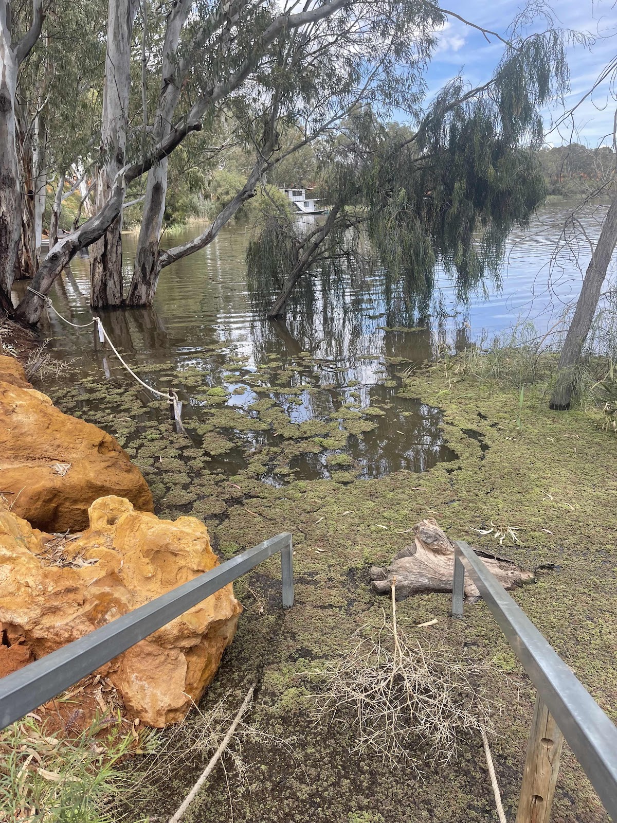
Checked out the river here to see how high it was


Checked out the area around the old Customs house which appears is now a private residence where house boats are rented out from
The track became less and less of a track so we decided we would turn back
So we retraced our steps to see where we had gone wrong
This snapshot of where we were on the old iPad with HEMA maps on showed that we were actually going in completely the wrong direction
Turns out that if we had continued on that track that was becoming less and less we would have come out here and we were so close to this point but unfortunately we did not know how much further we had to go and we did not know what state this road was in
So eventually back on the Muthro road to the Old Customs house
And to Chowilla
Checked out the river here to see how high it was
Checked out the area around the old Customs house which appears is now a private residence where house boats are rented out from


We started to go for a walk in the game reserve


But soon discovered the walk was all underwater

As were the campsites


We were also getting eaten alive by mosquitoes so very soon backtracked and got out of there

Back along the main road to Paringa


Where we stopped to look at the beautiful painted silos


And read about the people and things depicted on the silos


And about the artist and how the painting was done

Next we drove into Bert Dix Park

And drove along the road beside the river


To the end where the Paringa creek met the river Murray

So much water and more to come

On the way back we called in to look at lock number five


That was completely submerged


The old barge Bunyip was on display there so we had a look at that


Looked at this info at the weir


Then continued along the waterfront looking at all the houseboats moored there but not going anywhere


Views across to the lifting bridge from there

Came across this fishway


More views of the bridge and then we walked on it


Taking photos from the bridge we noticed this caravan park where part of a levy had been built


Spotted this map so thought we might go and check out the rest of the Trail

After checking the signage and area in this park on this side of the river


Drove back over the bridge into Renmark

And checked out water levels there


Discovered this historic paddle steamer was still moored next to the information centre


Driving around the area we saw these two young lads swimming in the water in a flooded park

Back over the bridge to Paringa

And back to the caravan park
This shows our travels for the day

This is the expanded area of our checking out Renmark

And this shows our thwarted attempts to reach McCabes corner that was never going to happen as there didn’t appear to be any way of reaching it because where we turned back at the border was private property. However if the Hema maps showed the detail that we can see here now we would have seen that we possibly could have got there further down the road. Unfortunately most of the time that we were using Hema maps on our trip there was little or no detail. I have had to redo all the maps on this blog to show all the detail with place names etc that weren’t showing at the time!!!

To enjoy a beautiful sunset after what had been a hot day
The temperature reading on display in the town said it was 30°


We decided to have a cooked dinner that we cooked on our stove at the van - we had bangers and mash with a glass of red and some of the slice that we had purchased from Nutbush for dessert
We decided to have a cooked dinner that we cooked on our stove at the van - we had bangers and mash with a glass of red and some of the slice that we had purchased from Nutbush for dessert

Comments
Post a Comment